- Project History
- Design & Research
- People
- Exhibitions
- Activities
- Publications
- View Project

- Contact
- Friends
- Links
Based on the visit, in early 1997, I began to make preparations to put together a research project whose objective would be to render a very precise digital replica of the Map. This would prove to be a daunting task given the intricacy of the details in the original as well as the deformations and damage that the passage of time had inflicted on it. From that moment I knew that a simple scanning job would not do and that we would need to use some type of stereo imaging technique.
After surveying the state-of-the art with 3D scanning and imaging at the time, I began to search all over the world for experts that would be interested in collaborating with the Media Lab Helsinki on a project of this nature. It was recommended that I should go and speak with Prof. Henrik Haggren from Institute of Photogrametry and Remote Sensing at the Helsinki University of Technology, about the matter. In the early summer of 1997, I visited Prof. Haggren and spent nearly three hours talking with him about the map and the project. diagram of photography for stereo viewing
Professor Haggren (Photography) agreed to create a method that we could use and that would give us the data we needed to do a three-dimensional, stereo, reconstruction. The method was particularly well suited since it was non-invasive and made use of traditional photographic equipment and archaeological technique. In this method, we used a studio camera (Sinar P) to shoot a series of overlapping, stereo images at close range. Color strips were used as a reference guide. We also used a custom made reticle that we created with an aluminum frame and black thread to keep track of position both in the photographing and subsequent stitching of the images.
On November of 1997, all the planning came together. I spent two days, with photographer Antti Huittinen, at the University of Uppsala Library studio facility photographing the map. The timing worked particularly well: The library’s museum was under renovation and the Map was scheduled to be removed from its old container and placed in a new unit for better preservation.
During the two-day photography session we produced hundreds of photographic materials, from the map, in the form of large format color slides and black and white negatives. Different light set ups were tried for the color slides and the black and white negatives. Back in Helsinki, before the whole batch of photographs was developed Antti performed control tests. Once we received the lot, with a fine point rapidograph and permanent ink, we proceeded to label each of the chromes on the upper right hand corner with a letter and a number that identifies its unique position in the reticle. Once this initial phase was over in late 1998, the materials were stored until the year 2002, when I completed my dissertation and work in the Illuminating History project.
In January of 2002 we were contacted by Adrian Locke, the curator of the Aztecs exhibition who was enthusiastic about our participation in the upcoming show at the Royal Academy of Art in London. At this point Janne Pietarila began working on the software design for the first interactive standalone version and Mariana Salgado was hired to scan and stitch together the images for the version that is now shown online.
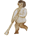
I continued my research into the origins of the Map as well as into the diverse reproductions and bibliography that have been created throughout the years. Among them we find that the Finnish explorer, A. H. Nordenskiöld created what was probably the first printed replica. Also, in the late 1890’s the British artist Adela C. Breton created the first comprehensive facsimile. This facsimile is included in a volume on ancient ruins in Mexico by Alfred P. Maudsley. Breton’s work is of interest because of the methodologies that as an artist she developed for the careful documentation of archaeological sites in Chichén Itzá and Teotihuacán.[1] [2]
I began the work on the interaction design and interface in 2002 when we created the first image of the Map for the Aztecs exhibition. Janne Pietarila and Mariana Salgado assisted me in this work. Janne designed the algorithm and programmed the interface. Mariana worked with me on the graphic user interface. She also organized a three-day long usability testing session at the Museum of Cultures in Helsinki, during the early Spring of 2003. In addition, Tanya Rodríguez did a fieldwork study of the different historical locations depicted in the map. The improvements that were made as a result of this work were incorporated into a new standalone version that traveled with the show from London to the Gropius Bau in Berlin and to the National Gallery in Bonn. At these later two venues, a movie version, created by Teijo Pellinen and Mariana Salgado was also shown. During this time we also had the opportunity to experiment with diverse forms of content development, including the creation of materials that combined sections of the Map with contemporary visual materials.
In 2003, my proposal to give a Master’s class on the creation of digital replicas as part of the International Cultural Heritage Informatics Meetings (ICHIM) 2003 at the School of the Louvre Museum in Paris was accepted. Professor Henrik Haggren and Mariana Salgado graciously agreed to participate in the class. Since then, work on the creation of the digital facsimile has accelerated. In 2004, for example, we produced the first interactive online version. During this year, I also worked on and proposed a concept for the creation of a video anthology of the legends of the historic center of Mexico City. The proposal received a first prize in the International Digital Storytelling competition held by the Nabi Art Center in South Korea with UNESCO.
In 2005, a demo of the fully stereographic replica was produced at the Helsinki University of Technology. Partly due to memory limitations, and to lack of funding, this demo is not yet available to the public.
Dissemination and Future Work
Our work with the Map of Mexico 1550 has enabled us to carry on rich explorations in the area of the intersection of arts, humanities and the sciences. Among the topics that we will continue to research with even more urgency are those of the cultural aspects and design of the interaction for a material artifact in the digital domain as well as that one of Open content development. This later represents a crucial building block in the digital collaborative research and education infrastructures of the future.
In the 1986 study on the pictography elements of the map, León-Portilla and Aguilera state that the definite facsimile of the Map is still to be made. Such a facsimile, we propose, would have to gather within the worldviews, aspirations, feelings and memories of the diverse constituencies that make this artifact a part of what is considered to be the heritage of humankind.
Footnotes
1. The Art of the Ruins, Adela Breton and the Temples of mexico, Giles, S. and Stewart, J., (eds.), Bristol, UK: City of Bristol Museum and Art Gallery, 1989.
2. "Maya Art for the Record", Scientific American, August 1990, 74-79.
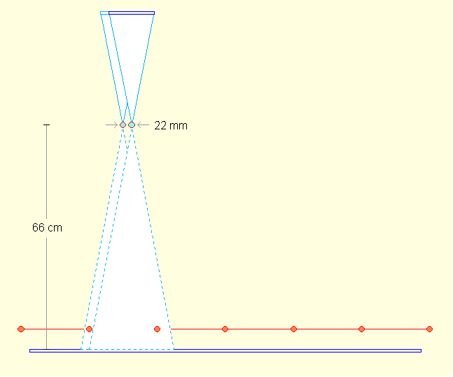
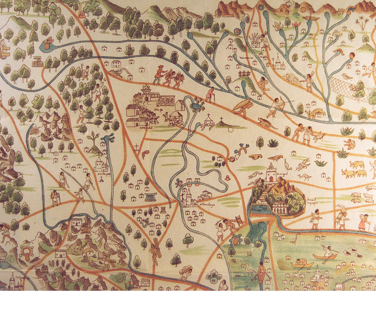
Figure 1. Diagram of how photography for stereo viewing was made
Figure 2. detail of Breton's map facsimile