- Project History
- Design & Research
- People
- Exhibitions
- Activities
- Publications
- View Project

- Contact
- Friends
- Links

The origins of this research project dates back to the early 90's, when I spent a year as a Fulbright scholar, doing fieldwork in the archives of Spain. At the time, the subject of my study was "Visualization in 16th century science in Spain and America." This was a topic that emerged after sifting through hundreds of documents pertaining the descriptions by the Spanish conquerors of the American territory. My proposal to the for the Fulbright was for the design of an information architecture that made use of metadata in order to display the European, Indigenous, and African points of view about the so-called Encounter between two worlds. As a result of this project, I created a prototype for an application in CD-ROM format and published and article ("A Simultaneous View of History: The Creation of A Hypermedia Database") in Leonardo about my work as an artist and researcher.
It was a very intense experience. While I lived in Seville, the mornings, from 7.30 to 13.00 were spent at the Archivo General de Indias. In the afternoons I either attended lessons on 16th century Latin palaeography at the University of Seville, or spent time at the library of the Escuela de Estudios Hispano Americanos. I was lucky, since the time of my tenure was a few months prior to the celebration of the Quincentennary, and there was a lot of interest and research activity. During the second semester of my stay, I also worked at the Biblioteca Nacional in Madrid, at the library of El Escorial, and at the Archivo del Real Observatorio de Cádiz. It was during this time that I came across the work of Alonso de Santa Cruz, royal cosmographer to his majesty, emperor Charles the V, of Spain and reputed author of the Map of Mexico 1550.
Alonzo de Santa Cruz
Not a lot is known about the early personal life of Santa Cruz. He studied cosmography in Salamanca. In 1525 he was named treasurer by the king to the first expedition that sailed to discover Maluco, Tharsis, Ophir and Cipango with Sebastian Cabot. The expedition used Martín Behain’s globe, then considered a masterwork, as guide. After his return to Seville in 1530, he remained there working at the Casa de Contratación, now the site of the Archivo General de Indias.[1] Around 1535 he designed an ingenious instrument to help determine longitude and by 1539 he was named Contino de la Casa Real by the king, a position that required him to travel frequently from Seville to the site of the Court.[2] By this time he had already started to work on the Islario General. In 1542, he completed a Mapamundi which is now part of the collection of Royal Library in Stockholm, Sweden. He maintained an active correspondence on scientific matters with D. Antonio de Mendoza, Viceroy of Mexico. He wrote a treatise about astrology, translated the works of Aristotle, drew maps of France, England, Scotland, Ireland, Germany, Hungary and Europe among others, as well as wrote a History of the Catholic Kings. Santa Cruz is reported to have died in 1567.[3]
In 1996 I was alerted by my tutor Dr. Derek Fewster on the existence of this ancient map of the city of Mexico at the Uppsala University Library. I did not realize until later that I would be given an opportunity to do further work with one of the Spanish scientists whose footsteps I had followed at the beginning of the decade. Shortly thereafter I contacted Dr. Margareta Lindgren then the Keeper of the Maps and Prints and expressed my desire to come to Uppsala to study the Map and perhaps even develop a project based on it. A few months later my wish became true and I was able to spend one full day examining the Map of Mexico 1550 (a.k.a Uppsala Map) closely. This experience proved to be invaluable from a design point of view, for I was able to gain an understanding of the physical characteristics of the artifact and begin to plan the measures that would be needed to create a digital replica.
Painted on two sheets of parchment joined together at the center, the map shows the city surrounded by water and with canals between its buildings. The clearly drawn roads over the mountains to other parts of the country permit us to retrace the routes taken by the Spanish conquerors. The map also provides abundant information about the ethnography and the flora and fauna of the region during the early colonial days.
The population is shown performing a variety of activities, such as woodcutting, canoeing, hunting, and fishing. The approximately 150 glyphs on the map, representing human and animal heads, feet, hands, circles and stars, are toponyms referring to name places.
The item seemed vaguely familiar since the style of making reminded me of many of the materials I had consulted during my year in the archive. In particular I was struck by the similarities between it and some of the maps that form a part of the corpus known as the Relaciones Geográficas de Indias. Though many legends circulate about its provenance, the map is reported to have been acquired by the Library. Both the Swedish anthropologist S. Linné and the historian Miguel León-Portilla and Carmen Aguilera have proposed that the Map is not the production of Alonso de Santa Cruz—he never visited Mexico and could not have on his own acquired the knowledge of the language and the geography that the Map exhibits—but rather, the work of members from the Aztec nobility working under the tutelage of Francisco de Sahagún.
Footnotes
1. de Santa Cruz, Alonso, Islario general de todas las islas del mundo; con un prólogo de D. Antonio Blázquez, Madrid: Impr. del Patronato de Huérfanos de Intendencia e Intervención Militares, 1918.
2. De la Puente y Olea, Manuel, Los Trabajos Geográficos de la Casa de la Contratación, Sevilla: Escuela Tipográfica y Libr. Salesianas, 1900.
3. Picatoste y Rodríguez, Felipe, Apuntes para una biblioteca científica española del siglo XVI. Estudios biográficos y bibliográficos de ciencias exactas físicas y naturals y sus imediatas aplicaciones en dicho siglo, Madrid, Imprenta y Fundición de Manuel Tello, 1891.
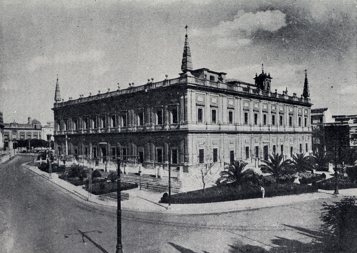
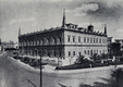

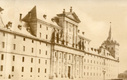
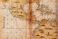
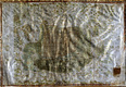
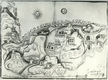
Figure 1. Archivo General de Indias
Figure 2. inside of Archivo General de Indias
Figure 3. El Escorial
Figure 4. Mapamundi of Santa Cruz
Figure 5. Map of Mexico 1550
Figure 6. Map of Xonotla 1581, image courtesy of Archivo General de Indias